Below is the final report for the project in its most complete form:
Adam Nelson and Dan Winters
Habitat Fragmentation Final Project Report
Introduction:
Habitat fragmentation represents one of the many significant threats to global biodiversity and there is widespread evidence that it is altering natural habitats through land conversion for other uses such as agriculture and unsustainable natural resource exploitation (Heilman et. al. 2002). In New York State, there are only a handful of geographic places that are relatively unfragmented including the Adirondack State Park. Rensselaer Plateau, and Catskills State Park while most other areas are experiencing some form of fragmentation (“Ecoregions of North America” 2016).
The goal of this project is to determine sections of unfragmented habitat within the state of New York. The habitat will be determined based on species. The main objective will be to conduct this analysis for 3 species, coyotes (Canis latrans), opossums (Didelphis virginiana), and salamanders (Caudata). Using data from the National Landcover Database we will determine where sections of unfragmented habitat are in New York based on the specific habitat needs of each species. Based on those needs and the suitable habitats in New York, we will generate maps of unfragmented habitats and potential habitats for those 3 species. These maps will allow us to analyze how fragmentation impacts the movements of specific kinds of species as each of our species has different ranges and movement capabilities.
Methods:
The GIS analysis that has taken place so far has included a number of steps. The first step was to acquire data from the National Landcover Database. That gave us the land cover for the entire state of New York, which allowed us to create maps of predicted suitable habitats throughout the state. The next step was to determine what makes a suitable habitat for our 3 target species. Multiple literature sources were collected and analyzed based on past studies of the habitat preferences and movement capabilities of each of the three species studied. Once the suitable land cover types for each species were determined, the National Landcover raster data was reclassified to suitable and not suitable habitats for each of the species. A nearest neighborhood analysis was then performed on the reclassified data to make the habitat data more accurate to get the final maps.
Results:
The land cover class data collected from the National Land Cover were use to create the following preliminary maps to understand where the least fragmented and forest covered areas are located in New York State.
Below are maps displaying various data that we are using in order to determine habitat fragmentation. We have found and mapped data such as the ecoregions of New York State, National Land Cover data, forest blocks and forest block linkages, and forested areas of New York State.
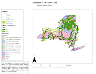
Figure 1:

This map shows the ecoregions of New York. The ecoregions were determined and named by the New York State Department of Environmental Conservation. The different ecoregions provide a small basis for determining forested areas.
Figure 2: 
This map shows information on land cover for the entire state. This data was taken from the National Landcover Database and then that raster was clipped to New York State. The different colors/numbers correspond to different types of landcover, as listed above.
Figure 3:
This map displays forest blocks and forest block linkages located in New York. Forest blocks are areas of forest that are continuous and not fragmented. The linkages are areas that are either not fragmented or minimally fragmented that connect the different forest blocks. Those linkages can provide ways for different species, such as coyotes, to move between different forest blocks.
Figure 4:
This map shows an analysis of forested areas of New York State. It was made by performing a nearest neighborhood analysis on the NLCD raster of land cover. The green areas represent anywhere that was determined to be a forest, regardless of forest type. The brown areas are areas that were determined to be non-forested. The forested/green area also represents what we have determined to be prime coyote habitat.
Next, the results of our research to define suitable coyote habitat land cover values as shown below:
Coyote:
National land cover values that represent suitable coyote habitat:
21- Developed, Open Space- mainly parks and golf courses
31- Barren Land
41- Deciduous Forest
42- Evergreen Forest
43- Mixed Forest
52- Shrub/ Scrub
71- Grassland/ Herbaceous
81- Pasture/ Hay
82- Cultivated Crops
90- Woody Wetlands
95- Emergent Herbaceous Wetlands
National land cover values that represent unsuitable coyote habitat:
11- Open Water
23- Developed, Medium Intensity
24- Developed, High Intensity
These current results of our reclassification analyses of the land cover layers of NY to select suitable coyote habitat are shown in the following map:
Figure 5:

Opossum:
Results of our research to define suitable opossum habitat land cover values:
Suitable habitat land classes for the Virginia Opossum (Didelphis virginiana)
include:
21- Developed, Open Space- mainly parks and golf courses
31- Barren Land
41- Deciduous Forest
42- Evergreen Forest
43- Mixed Forest
52- Shrub/ Scrub
71- Grassland/ Herbaceous
82- Cultivated Crops
90- Woody Wetlands
95- Emergent Herbaceous Wetlands
National land cover values that represent unsuitable Virginia Opossum habitat:
11- Open Water
23- Developed, Medium Intensity
24- Developed, High Intensity
81- Pasture/ Hay
These current results of our reclassification analyses of the land cover layers of NY to select suitable Opossum habitat are shown in the following map:
Figure 6:

Salamander:
Suitable land cover types that salamanders can inhabit in NY can be seen below followed by unsuitable land cover types:
National land cover values that represent suitable habitat land classes for NY salamanders:
41- Deciduous Forest
43- Mixed Forest
90- Woody Wetlands
95- Emergent Herbaceous Wetlands
National land cover values that represent unsuitable NY salamander habitat:
11- Open Water
23- Developed, Medium Intensity
24- Developed, High Intensity
42- Evergreen Forest
52- Shrub/ Scrub
71- Grassland/ Herbaceous
81- Pasture/ Hay
82- Cultivated Crops
Figure 7:

Figure 8: Tree Density Analysis of The Adirondack State Park, Catskills State Park, Allegheny, and Rensselaer Plateau.

Future Work:
Future paths that this study could take would be the incorporation of other pilot species in New York to see how they are impacted by fragmentation based on their movement capabilities and habitat preferences. Another possible method of analysis would be to compare species that are habitat generalists with many suitable habitat types to species with specific habitat preferences suited by only a few land cover classes.
Conclusion:
This GIS analysis study on habitat fragmentation helps prove that the fragmentation of various habitats does affect the amount of suitable habitat available to each species differently. Many factors play into the amount of suitable habitat that a species finds including their habitat needs and movement capabilities in the face of expanding human development.
In this analysis, the widespread movement capabilities and high adaptability to diverse natural and urbanized habitats allowed the coyote (Canis latrans) to have the largest amount of suitable habitat. This serves as evidence that this species is adapting to fragmentation and learning to live among humans and the widespread development of lands we have created (Atwood et. al. 2004).
The second species, the opossum (Didelphis Virginiana) is also a habitat generalist able to adapt to a diverse amount of land cover types and increased urbanization based on the widespread suitable habitat they possess in New York, although it is less than that of the coyote (Canis latrans). This species experiences slightly more of a negative impact from fragmentation because they are more vulnerable on roads as they can’t cross as quickly and are harder for cars to spot resulting in their deaths (Virginia Opossum - Didelphis Virginiana).
The third species, all salamander species, is most impacted by habitat fragmentation because of their specific habitat preferences and poor movement capabilities. Salamanders require moist habitats with water bodies for breeding which are found only in specific habitats like wetlands and forest floors where this moisture can be maintained (SPCN Amphibians). Salamanders also stand no chance of crossing roads that go through their habitats so any roads will fragment their habitats significantly (Guerry & Hunter 2002). Therefore, land conservation efforts will be most beneficial to the salamander species as they prove to be the least adaptable, more vulnerable species out of the three species analyzed.
Final Poster:

Works Cited:
Atwood, Todd C., Harmon P. Weeks, and Thomas M. Gehring. "Spatial Ecology Of Coyotes Along A Suburban-To-Rural Gradient." Journal of Wildlife Management 68.4 (2004): 1000-009. BioOne. Web. 31 Mar. 2016.
“Ecoregions of North America." Ecoregion Maps and GIS Resources. US Environmental Protection Agency, 21 Feb. 2016. Web. 10 Mar. 2016.
ESRI Data and Maps (2010) [DVD]. ESRI, Inc., Redlands, CA.
Guerry, Anne D., and Malcolm L. Hunter. "Amphibian Distributions in a Landscape of Forests and Agriculture: An Examination of Landscape Composition and Configuration." Conservation Biology 16.3 (2002): 745-54. Web.
Heilman, Gerald E., James R. Strittholt, Nicholas C. Slosser, and Dominick A. Dellasala. "Forest Fragmentation of the Conterminous United States: Assessing Forest Intactness through Road Density and Spatial Characteristics." BioScience 52.5 (2002): 411. Web. 10 Mar. 2016.
"Multi-Resolution Land Characteristics Consortium (MRLC)." Multi-Resolution Land Characteristics Consortium (MRLC). US Geological Survey, 28 Mar. 2016. Web. 31 Mar. 2016.
"SPCN Amphibians."Www.dec.ny.gov/docs/wildlife_pdf/spcnamphibians.pdf. New York Department of Environmental Conservation, 2007. Web. 21 Apr. 2016.
"Virginia Opossum - Didelphis Virginiana." Virginia Opossum. New Hampshire Public Television, 2016. Web. 06 Apr. 2016.
Appendix:
Coordinate System: UTM Zone 18N
Project Folder: Computer/ArcGIS (G:)/Group_Projects/Coyote